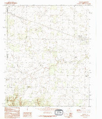
1990 Map of Goodlett
USGS Topo · Published 1995About this map
The boundary intersection of Childress, Hardeman, and Cottle counties defines this North Texas landscape. The terrain is characterized by the winding path of South Groesbeck Creek and the notable rise of Hepsidam Hill to the south. Small rural communities like Goodlett and Wheatland serve as the primary anchors of settlement, while smaller locales like Punkin Center and Lazare dot the outskirts. The map illustrates a transitional period in the late 20th century where traditional agricultural land patterns persist alongside established infrastructure, including a prominent Roadside Park and several cemeteries that provide vital clues for genealogical research. The drainage patterns of Spring Canyon further emphasize the seasonal water flow typical of this region's prairie environment.
Find a feature on this map
12 named features on this map. Tap any name to fly to it.
Don’t see what you’re looking for? This feature index may not catch every label — zoom into the map to look around manually.
Map Details
Editions of this 1990 Goodlett Map
This is the sole edition of this map. No revisions or reprints were ever made.
Other maps of this area

1927 · Quanah 3-a
USGS Topo · 1:48,000

1927 · Quanah 3-b
USGS Topo · 1:48,000

1932 · Vivian
USGS Topo · 1:62,500

1954 · Plainview
USGS Topo · 1:250,000

1955 · Lawton
USGS Topo · 1:250,000

1958 · Plainview
USGS Topo · 1:250,000

1960 · Goodlett
USGS Topo · 1:62,500

1960 · Teacup Mountain
USGS Topo · 1:62,500

1967 · Kirkland South
USGS Topo · 1:24,000

1967 · Kirkland North
USGS Topo · 1:24,000