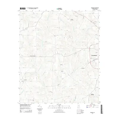
2014 Map of Goodman
USGS Topo · Published 2014About this map
Enterprise anchors the eastern edge of this Alabama landscape, where the Enterprise Municipal Airport sits just south of the city's expanding residential grid. The terrain is defined by a dense network of tributaries including Double Bridges Cr, Blanket Cr, and Little Double Bridges Cr, which have historically shaped the settlement patterns of Coffee County. Small crossroads and family landmarks are scattered throughout the rural landscape, including Goodman, New Brockton, and Battens Crossroads. Local heritage is deeply rooted in the numerous cemeteries and churches that serve as focal points for the surrounding rural communities, such as Goodman Cem, Morning Star Cem, and Pleasant Ridge Cem. The presence of features like Peacock Mill Br and Wooten Mill Cr suggests a legacy of water-powered industry that once supported these farming townships.
Find a feature on this map
133 named features on this map. Tap any name to fly to it.
Don’t see what you’re looking for? This feature index may not catch every label — zoom into the map to look around manually.
Map Details
Editions of this 2014 Goodman Map
This is the sole edition of this map. No revisions or reprints were ever made.
Other maps of this area

1942 · Enterprise
USGS Topo · 1:125,000

1950 · Enterprise
USGS Topo · 1:62,500

1953 · Andalusia
USGS Topo · 1:250,000

1953 · Dothan
USGS Topo · 1:250,000

1954 · Dothan
USGS Topo · 1:250,000

1955 · Dothan
USGS Topo · 1:250,000

1957 · Andalusia
USGS Topo · 1:250,000

1957 · Geneva
USGS Topo · 1:62,500

1957 · Bellwood
USGS Topo · 1:24,000
1957 · Coffee Springs
USGS Topo · 1:24,000