
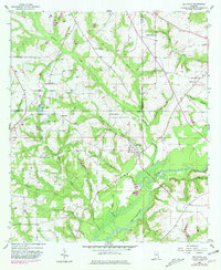
1957 Map of Bellwood
USGS Topo · Published 1959About this map
The Choctawhatchee River defines the landscape of southeastern Alabama in the late 1950s, snaking through a network of creeks and branches at the intersection of Coffee, Dale, and Geneva counties. This area is characterized by scattered rural settlements such as Bellwood and Scranton, supported by a strong foundation of community landmarks. Numerous country churches, including Cool Springs Ch, Sardis Ch, and St Pauls Ch, serve as focal points for local genealogy and history research. Along the lowlands near the river, several Sandpits indicate small-scale industrial activity, while named water bodies like Lake Jeanette and Lake Fox punctuate the terrain. The map provides a detailed view of the drainage patterns from Brackin Mill Creek and Roaring Creek, offering a look at the rural road networks and family-named landmarks that connected these agricultural communities before modern development.
Find a feature on this map
36 named features on this map. Tap any name to fly to it.
Don’t see what you’re looking for? This feature index may not catch every label — zoom into the map to look around manually.
Map Details
Editions of this 1957 Bellwood Map
2 editions found
Other maps of this area

1942 · Enterprise
USGS Topo · 1:125,000

1948 · Ozark
USGS Topo · 1:62,500

1950 · Ozark
USGS Topo · 1:62,500

1950 · Enterprise
USGS Topo · 1:62,500

1953 · Dothan
USGS Topo · 1:250,000

1954 · Dothan
USGS Topo · 1:250,000

1955 · Dothan
USGS Topo · 1:250,000

1957 · Geneva
USGS Topo · 1:62,500

1957 · Hartford
USGS Topo · 1:62,500
1957 · Hartford
USGS Topo · 1:24,000