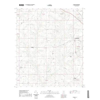
2020 Map of Goodman
USGS Topo · Published 2020About this map
New Brockton and the western edge of Enterprise anchor this Coffee County landscape, where the town limits meet a network of rural crossroads and family cemeteries. The terrain is defined by a dense dendritic drainage system, with Double Bridges Cr and Little Double Bridges Cr carving through the center of the sheet. These waterways, along with others like Peacock Mill Br and Wooten Mill Cr, suggest a legacy of water-powered industry in the region's earlier history. Small communities such as Goodman, Turner Crossroads, and Battens Crossroads serve as local hubs for the surrounding farmsteads. Significant local history is preserved in numerous burial grounds scattered across the townships, including Morning Star Cem, Pleasant Ridge Cem, and Asbury Cem. The southeastern portion of the map is notable for the Enterprise Municipal Airport, illustrating the modern infrastructure that connects this agricultural corridor to the wider world.
Find a feature on this map
135 named features on this map. Tap any name to fly to it.
Don’t see what you’re looking for? This feature index may not catch every label — zoom into the map to look around manually.
Map Details
Editions of this 2020 Goodman Map
This is the sole edition of this map. No revisions or reprints were ever made.
Other maps of this area

1942 · Enterprise
USGS Topo · 1:125,000

1950 · Enterprise
USGS Topo · 1:62,500

1953 · Andalusia
USGS Topo · 1:250,000

1953 · Dothan
USGS Topo · 1:250,000

1954 · Dothan
USGS Topo · 1:250,000

1955 · Dothan
USGS Topo · 1:250,000

1957 · Andalusia
USGS Topo · 1:250,000

1957 · Geneva
USGS Topo · 1:62,500

1957 · Bellwood
USGS Topo · 1:24,000
1957 · Coffee Springs
USGS Topo · 1:24,000