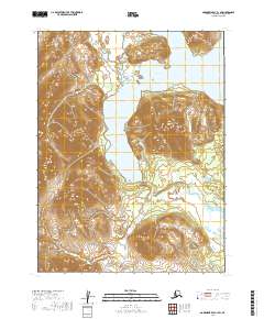
2019 Map of Goodnews Bay A-1 SW
USGS Topo · Published 2019About this map
Sugtutlik Peak rises as a prominent landmark in this segment of the Dillingham Census Area, overlooking a landscape defined by its glacial hydrology. The massive Amanka Lake dominates the central-east portion of the terrain, acting as a terminal point for the Ongoke River, which meanders from the north. Further south, the Igushik River cuts across the lower quadrants, illustrating the complex drainage patterns of the Bristol Bay region. This 2019 survey provides a precise view of the topography before any modern infrastructure development, preserving the unmodified shoreline and river courses exactly as they have existed for generations.
Find a feature on this map
9 named features on this map. Tap any name to fly to it.
Don’t see what you’re looking for? This feature index may not catch every label — zoom into the map to look around manually.
Map Details
Editions of this 2019 Goodnews Bay A-1 SW Map
This is the sole edition of this map. No revisions or reprints were ever made.
Other maps of this area

1945 · Nushagak Bay
USGS Topo · 1:250,000

1948 · Nushagak Bay D-4
USGS Topo · 1:63,360

1949 · Nushagak Bay
USGS Topo · 1:250,000

1950 · Nushagak Bay D-5
USGS Topo · 1:63,360

1951 · Goodnews
USGS Topo · 1:250,000

1951 · Nushagak Bay
USGS Topo · 1:250,000

1952 · Nushagak Bay D-4
USGS Topo · 1:63,360

1964 · Nushagak Bay
USGS Topo · 1:250,000
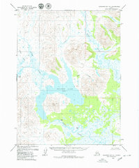
1979 · Goodnews Bay A-1
USGS Topo · 1:63,360

1979 · Goodnews Bay
USGS Topo · 1:250,000