
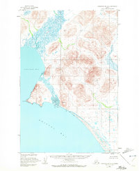
1950 Map of Nushagak Bay D-5
USGS Topo · Published 1956About this map
The Kulukak River and Tuklung River dominate this coastal landscape as it appeared in the mid-20th century, winding through tidal marshlands toward the northern reaches of Bristol Bay. Mapped by the U.S. Coast and Geodetic Survey using aerial photography from the late 1940s, the terrain shows a stark contrast between the complex, water-logged drainage basins and the steep topographic ridges that rise sharply from the shoreline. The inclusion of Kulukak Pt and the sheltered waters of Tvativak Bay highlights a region defined by its marine access and the natural harbors of Kulukak Bay. This survey provides a precise look at the hydrology of the Alaska coastline before modern development, recording the exact placement of river bends and shoreline contours that are essential for understanding the environmental history and navigational challenges of this remote corner of the Third Judicial Division.
Find a feature on this map
6 named features on this map. Tap any name to fly to it.
Don’t see what you’re looking for? This feature index may not catch every label — zoom into the map to look around manually.
Map Details
Editions of this 1950 Nushagak Bay D-5 Map
2 editions found
Other maps of this area

1945 · Nushagak Bay
USGS Topo · 1:250,000

1948 · Nushagak Bay D-4
USGS Topo · 1:63,360

1948 · Nushagak Bay C-4 And C-5
USGS Topo · 1:63,360

1949 · Nushagak Bay
USGS Topo · 1:250,000

1950 · Nushagak Bay C-4 And C-5
USGS Topo · 1:63,360

1950 · Nushagak Bay D-6
USGS Topo · 1:63,360

1951 · Goodnews
USGS Topo · 1:250,000

1951 · Nushagak Bay
USGS Topo · 1:250,000

1952 · Nushagak Bay D-4
USGS Topo · 1:63,360

1964 · Nushagak Bay
USGS Topo · 1:250,000