
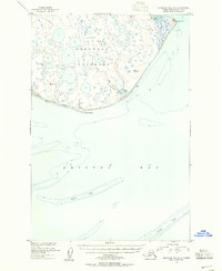
1950 Map of Nushagak Bay C-4 And C-5
USGS Topo · Published 1955About this map
Nushagak Peninsula is defined by a dense network of countless small ponds and lakes, a characteristic landscape of the Alaska coastal tundra as mapped in the mid-20th century. Bordering the expansive waters of Bristol Bay, this area shows a complex aquatic system where the Igushik River and Tununuk River wind through low-lying terrain. Topography is largely determined by minor elevation changes, marked by several triangulation stations such as VABM 209 Peninsula and VABM 154 Pike. These benchmarks were essential for the U. S. Coast and Geodetic Survey during their 1950 coastal mapping efforts. The map reveals the isolation of Kikertalik Lake and other unnamed water bodies, providing a detailed record of the shoreline and inland hydrology before modern environmental shifts altered these sensitive Arctic drainage patterns.
Find a feature on this map
10 named features on this map. Tap any name to fly to it.
Don’t see what you’re looking for? This feature index may not catch every label — zoom into the map to look around manually.
Map Details
Editions of this 1950 Nushagak Bay C-4 And C-5 Map
This is the sole edition of this map. No revisions or reprints were ever made.
Other maps of this area

1945 · Nushagak Bay
USGS Topo · 1:250,000

1948 · Nushagak Bay D-4
USGS Topo · 1:63,360

1948 · Nushagak Bay D-3
USGS Topo · 1:63,360

1948 · Nushagak Bay C-4 And C-5
USGS Topo · 1:63,360

1949 · Nushagak Bay
USGS Topo · 1:250,000

1950 · Nushagak Bay B-4
USGS Topo · 1:63,360

1950 · Nushagak Bay C-3
USGS Topo · 1:63,360
1950 · Nushagak Bay B-3
USGS Topo · 1:63,360

1950 · Nushagak Bay D-5
USGS Topo · 1:63,360

1951 · Nushagak Bay
USGS Topo · 1:250,000