
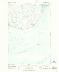
1948 Map of Nushagak Bay C-4 And C-5
USGS Topo · Published 1975About this map
The Nushagak Peninsula stretches across this mid-century topographic survey, revealing a landscape defined by an intricate network of wetlands and small ponds along the coast of Bristol Bay. Mapped from 1948 aerial photography, the terrain is notably flat, characterized by swampy areas and numerous unnamed water bodies that surround the prominent Kikertalik Lake. The survey focuses on geodetic control and coastal features rather than human settlements, with several vertical angle bench marks (VABM) established as reference points for future navigation and mapping. These include VABM 154 Pike and VABM 214 Bristol North Base along the northwestern shoreline, as well as VABM 110 Judith toward the southern end of the peninsula. The isolation of the region is evident in the lack of established roads or trails, leaving the Tunning River as one of the few named drainage features in this remote Alaskan environment.
Find a feature on this map
9 named features on this map. Tap any name to fly to it.
Don’t see what you’re looking for? This feature index may not catch every label — zoom into the map to look around manually.
Map Details
Editions of this 1948 Nushagak Bay C-4 And C-5 Map
This is the sole edition of this map. No revisions or reprints were ever made.
Other maps of this area

1945 · Nushagak Bay
USGS Topo · 1:250,000

1948 · Nushagak Bay D-4
USGS Topo · 1:63,360

1948 · Nushagak Bay D-3
USGS Topo · 1:63,360

1949 · Nushagak Bay
USGS Topo · 1:250,000

1950 · Nushagak Bay B-4
USGS Topo · 1:63,360

1950 · Nushagak Bay C-3
USGS Topo · 1:63,360

1950 · Nushagak Bay C-4 And C-5
USGS Topo · 1:63,360
1950 · Nushagak Bay B-3
USGS Topo · 1:63,360

1950 · Nushagak Bay D-5
USGS Topo · 1:63,360

1951 · Nushagak Bay
USGS Topo · 1:250,000