
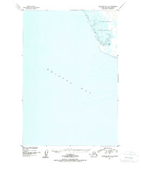
1950 Map of Nushagak Bay B-4
USGS Topo · Published 1955About this map
The Nushagak Peninsula dominates the northeastern corner of this 1950 coastal survey, revealing a landscape defined by intricate tidal flats and marshy terrain. Produced through a collaboration between the U.S. Coast and Geodetic Survey and the Geological Survey, the map focuses on the complex transition between land and the sea within Bristol Bay. These hydrographic details, compiled from USC&GS charts and 1947 aerial photography, document the shifting Mud banks and shallow waters that characterize the region's shoreline. The absence of roads or established settlements emphasizes the remote nature of the Alaskan coast during the mid-century period, providing a precise baseline for studying coastal erosion and environmental change in this subarctic environment.
Find a feature on this map
3 named features on this map. Tap any name to fly to it.
Don’t see what you’re looking for? This feature index may not catch every label — zoom into the map to look around manually.
Map Details
Editions of this 1950 Nushagak Bay B-4 Map
2 editions found
Other maps of this area

1945 · Nushagak Bay
USGS Topo · 1:250,000

1948 · Nushagak Bay C-4 And C-5
USGS Topo · 1:63,360

1949 · Nushagak Bay
USGS Topo · 1:250,000

1950 · Nushagak Bay C-3
USGS Topo · 1:63,360

1950 · Nushagak Bay C-4 And C-5
USGS Topo · 1:63,360
1950 · Nushagak Bay B-3
USGS Topo · 1:63,360

1951 · Nushagak Bay
USGS Topo · 1:250,000

1964 · Nushagak Bay
USGS Topo · 1:250,000
2019 · Nushagak Bay C-4 SE
USGS Topo · 1:25,000
2019 · Nushagak Bay B-3 NW
USGS Topo · 1:25,000