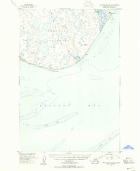
1950 Map of Nushagak Bay B-3
USGS Topo · Published 1955About this map
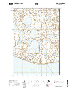
Nushagak Peninsula is defined by a labyrinth of countless unnamed tundra ponds and wetlands in this mid-century topographic record. Fronting the waters of Bristol Bay, the coastline is a shifting environment of mudflats and prominent maritime landmarks like Cape Constantine and Protection Point. Surveyed by the U.S. Coast and Geodetic Survey using 1948 aerial photography, the map captures the intricate shoreline before major geomorphological shifts. Maritime hazards are carefully charted, including the expansive Sterling Shoal and Ustiugof Shoal, which were critical for navigators in these subarctic waters. The presence of several Triangulation Stations, such as VABM Nush and VABM Bee, indicates the rigorous surveying efforts required to map this remote coastal stretch of the Alaska-Third Judicial Division.
Find a feature on this map
18 named features on this map. Tap any name to fly to it.
Don’t see what you’re looking for? This feature index may not catch every label — zoom into the map to look around manually.
Map Details
Editions of this 1950 Nushagak Bay B-3 Map
3 editions found
Other maps of this area

1945 · Nushagak Bay
USGS Topo · 1:250,000

1948 · Nushagak Bay C-4 And C-5
USGS Topo · 1:63,360

1949 · Nushagak Bay
USGS Topo · 1:250,000

1950 · Nushagak Bay B-4
USGS Topo · 1:63,360

1950 · Nushagak Bay C-3
USGS Topo · 1:63,360

1950 · Nushagak Bay C-4 And C-5
USGS Topo · 1:63,360

1951 · Nushagak Bay
USGS Topo · 1:250,000

1964 · Nushagak Bay
USGS Topo · 1:250,000
2019 · Nushagak Bay C-4 SE
USGS Topo · 1:25,000
2019 · Nushagak Bay B-3 NW
USGS Topo · 1:25,000