
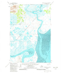
1948 Map of Nushagak Bay D-3
USGS Topo · Published 1975About this map
Acorn Peak rises above the tidal lowlands of Southwest Alaska, anchoring a landscape dominated by the winding channels of the Snake River and Weary River. Surveyed shortly after World War II, the map reveals the complex hydrography of the region as it enters Nushagak Bay. Broad mudflats define the shoreline, particularly where the Igushik River flows past Igushik Ridge to meet the tide. This survey, compiled from USC&GS aerial photography and hydrographic charts, records the natural state of the delta before significant modern development. The positioning of triangulation stations like VABM 49 Snake and VABM 62 Point highlights the importance of this area for maritime navigation and coastal monitoring during the mid-20th century.
Find a feature on this map
9 named features on this map. Tap any name to fly to it.
Don’t see what you’re looking for? This feature index may not catch every label — zoom into the map to look around manually.
Map Details
Editions of this 1948 Nushagak Bay D-3 Map
2 editions found
Other maps of this area

1945 · Nushagak Bay
USGS Topo · 1:250,000

1948 · Nushagak Bay D-4
USGS Topo · 1:63,360

1948 · Nushagak Bay C-4 And C-5
USGS Topo · 1:63,360

1949 · Nushagak Bay
USGS Topo · 1:250,000

1950 · Nushagak Bay C-3
USGS Topo · 1:63,360

1950 · Nushagak Bay C-4 And C-5
USGS Topo · 1:63,360

1951 · Dillingham
USGS Topo · 1:250,000

1951 · Goodnews
USGS Topo · 1:250,000

1951 · Nushagak Bay
USGS Topo · 1:250,000

1952 · Nushagak Bay D-3
USGS Topo · 1:63,360