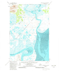
1948 Map of Nushagak Bay D-3
USGS Topo · Published 1982About this map
The Snake River and Igushik River dominate this coastal landscape, winding through a complex network of wetlands and mudflats as they drain into the expansive Nushagak Bay. Photographed from the air in the late 1940s, the terrain transitions from the low-lying estuaries of the Togiak National Wildlife Refuge to the higher elevations of Acorn Peak and Igushik Ridge in the west. A lonely Cannery sits along the shoreline, signifying the area's historical reliance on the salmon industry of the Bristol Bay region. The intricate mapping of the Weary River and the inclusion of survey markers like Poke VABM 52 and Snake VABM 49 reveal the precision required to document this shifting tidal environment during the post-war era of Alaskan charting.
Find a feature on this map
14 named features on this map. Tap any name to fly to it.
Don’t see what you’re looking for? This feature index may not catch every label — zoom into the map to look around manually.
Map Details
Editions of this 1948 Nushagak Bay D-3 Map
2 editions found
Other maps of this area

1945 · Nushagak Bay
USGS Topo · 1:250,000

1948 · Nushagak Bay D-4
USGS Topo · 1:63,360

1948 · Nushagak Bay D-3
USGS Topo · 1:63,360

1948 · Nushagak Bay C-4 And C-5
USGS Topo · 1:63,360

1949 · Nushagak Bay
USGS Topo · 1:250,000

1950 · Nushagak Bay C-3
USGS Topo · 1:63,360

1950 · Nushagak Bay C-4 And C-5
USGS Topo · 1:63,360

1951 · Dillingham
USGS Topo · 1:250,000

1951 · Goodnews
USGS Topo · 1:250,000

1951 · Nushagak Bay
USGS Topo · 1:250,000