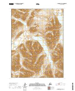
2020 Map of Goodnews Bay C-4 NW
USGS Topo · Published 2020About this map
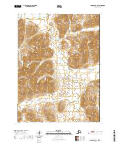
Nagugun Lake dominates the central basin of this Bethel Census Area landscape, serving as a primary hydrological focal point for the surrounding glacial-carved terrain. This 2020 survey illustrates a complex network of freshwater systems, where the outflow of Nagugun Cr drains the southern reaches while Klak Lake and Klak Cr define the northwestern geography. The high-altitude lakes and their connecting streams represent a largely unpeopled wilderness, delineated by the Public Land Survey System grids of t5s r66w and t6s r65w. To the northeast, the presence of Kanuktik Lake and Kanuktik Cr further indicates the watershed patterns characteristic of this remote portion of southwestern Alaska. The map provides a detailed topographic record of the steep ridges and drainage basins that shape this untouched environment.
Find a feature on this map
10 named features on this map. Tap any name to fly to it.
Don’t see what you’re looking for? This feature index may not catch every label — zoom into the map to look around manually.
Map Details
Editions of this 2020 Goodnews Bay C-4 NW Map
This is the sole edition of this map. No revisions or reprints were ever made.
Other maps of this area

1951 · Goodnews
USGS Topo · 1:250,000

1954 · Goodnews C-4
USGS Topo · 1:63,360

1954 · Goodnews D-4
USGS Topo · 1:63,360

1954 · Goodnews D-5
USGS Topo · 1:63,360

1979 · Goodnews Bay C-5
USGS Topo · 1:63,360

1979 · Goodnews Bay
USGS Topo · 1:250,000
2020 · Goodnews Bay C-4 NE
USGS Topo · 1:25,000
2020 · Goodnews Bay D-4 SE
USGS Topo · 1:25,000
2020 · Goodnews Bay C-4 SW
USGS Topo · 1:25,000
2020 · Goodnews Bay C-5 NE
USGS Topo · 1:25,000