
1954 Map of Goodnews C-4
USGS Topo · Published 1965About this map
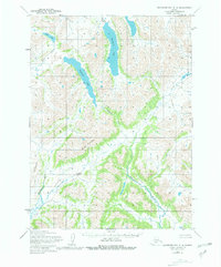
The Ahun Mountains dominate this 1950s interior landscape, defining a complex drainage system within the Dillingham region. Glacial carving is evident in the elongated forms of Nagugun Lake and Kanuktik Lake, which feed into a network of vital waterways including the Goodnews River. The map reveals a land without roads or established trails at the time of survey, where movement was dictated by the natural corridors of the Lumiumavik River and Nayorurun River. Higher elevations are marked by distinct peaks such as Mitlak Mountain and Nigag Mountain, while lower basins are home to smaller water bodies like Klak Lake and its corresponding Klak Creek. This topographic record provides a baseline for understanding the hydrologic connectivity of the region before significant modern change, showing the raw state of the southwestern Alaskan interior.
Find a feature on this map
12 named features on this map. Tap any name to fly to it.
Don’t see what you’re looking for? This feature index may not catch every label — zoom into the map to look around manually.
Map Details
Editions of this 1954 Goodnews C-4 Map
2 editions found
Other maps of this area

1951 · Goodnews
USGS Topo · 1:250,000

1954 · Goodnews B-3
USGS Topo · 1:63,360

1954 · Goodnews D-4
USGS Topo · 1:63,360

1954 · Goodnews D-5
USGS Topo · 1:63,360

1979 · Goodnews Bay C-5
USGS Topo · 1:63,360

1979 · Goodnews Bay D-3
USGS Topo · 1:63,360

1979 · Goodnews Bay B-5
USGS Topo · 1:63,360

1979 · Goodnews Bay C-3
USGS Topo · 1:63,360

1979 · Goodnews Bay
USGS Topo · 1:250,000
1979 · Goodnews Bay B-4
USGS Topo · 1:63,360