
1954 Map of Goodnews B-3
USGS Topo · Published 1965About this map
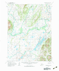
Kashiagamiut stands as a primary point of interest along the sweeping curves of the Togiak River in this mid-century survey of southwestern Alaska. The landscape is defined by an intricate network of waterways and glacial features, including the sprawling Pungokepuk Lake and its outlet at Pungokepuk Creek. Several major tributaries converge in this drainage basin, such as the Narogurum River, Kashalak River, and Ongivinuk River. Based on aerial photography from the early 1950s, this Army Map Service data reveals a vast wilderness where land lines remained unsurveyed and unmarked by the Bureau of Land Management. The map captures the region's physical geography before modern development, documenting the traditional site of Kashiagamiut at a sharp bend in the river.
Find a feature on this map
7 named features on this map. Tap any name to fly to it.
Don’t see what you’re looking for? This feature index may not catch every label — zoom into the map to look around manually.
Map Details
Editions of this 1954 Goodnews B-3 Map
2 editions found
Other maps of this area

1951 · Goodnews
USGS Topo · 1:250,000

1954 · Goodnews C-2
USGS Topo · 1:63,360

1954 · Goodnews C-4
USGS Topo · 1:63,360

1954 · Goodnews A-4
USGS Topo · 1:63,360

1954 · Goodnews A-3
USGS Topo · 1:63,360

1979 · Goodnews Bay B-2
USGS Topo · 1:63,360

1979 · Goodnews Bay C-3
USGS Topo · 1:63,360

1979 · Goodnews Bay
USGS Topo · 1:250,000
1979 · Goodnews Bay A-2
USGS Topo · 1:63,360
1979 · Goodnews Bay B-4
USGS Topo · 1:63,360