
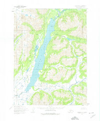
1954 Map of Goodnews C-2
USGS Topo · Published 1965About this map
Togiak Lake dominates this 1950s landscape, serving as the central drainage basin for a network of glacial valleys and alpine peaks. The survey, field annotated in 1954, reveals a topography defined by steep elevations like Pistuk Peak and the established survey point at Buzzard Azimuth. Water is the primary sculptor of the region, with Kiyukluk Creek feeding into the main lake body from the west. To the south, the system transitions into the headwaters of the Togiak River, which is joined by the Ongivinuk River. This map captures a remote Alaskan wilderness before significant modern infrastructure, showing the natural hydrologic connections that have historically dictated movement and subsistence in the Dillingham region.
Find a feature on this map
6 named features on this map. Tap any name to fly to it.
Don’t see what you’re looking for? This feature index may not catch every label — zoom into the map to look around manually.
Map Details
Editions of this 1954 Goodnews C-2 Map
2 editions found
Other maps of this area

1951 · Goodnews
USGS Topo · 1:250,000

1954 · Goodnews B-3
USGS Topo · 1:63,360

1979 · Goodnews Bay D-3
USGS Topo · 1:63,360

1979 · Goodnews Bay B-2
USGS Topo · 1:63,360

1979 · Goodnews Bay D-1
USGS Topo · 1:63,360

1979 · Goodnews Bay C-3
USGS Topo · 1:63,360

1979 · Goodnews Bay B-1
USGS Topo · 1:63,360

1979 · Goodnews Bay
USGS Topo · 1:250,000

1979 · Goodnews Bay C-1
USGS Topo · 1:63,360

1979 · Goodnews Bay D-2
USGS Topo · 1:63,360