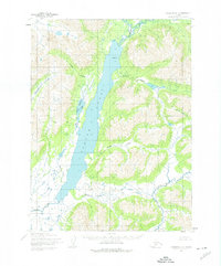
1954 Map of Goodnews C-2
USGS Topo · Published 1975About this map
Togiak Lake dominates this mid-century landscape in the Ahklun Mountains region, serving as the central basin for a complex system of glacial and mountain streams. The water network is defined by the Izavieknik R entering from the north and the wide Togiak River draining the lake's southern end. This 1954 field-annotated map reveals a roadless wilderness where the geography is recorded through natural landmarks like the prominent North Spit and Pistuk Peak. Local drainage patterns are exceptionally detailed, showing numerous tributaries such as Kiyukluk Creek, Bruin Creek, and Jondik Creek feeding into the main lake and the West Togiak Lake sub-basin. The survey reflects a period before modern development, capturing the hydrologic character of the Togiak National Wildlife Refuge area in its undeveloped state, as documented by the Army Map Service and the Geological Survey.
Find a feature on this map
14 named features on this map. Tap any name to fly to it.
Don’t see what you’re looking for? This feature index may not catch every label — zoom into the map to look around manually.
Map Details
Editions of this 1954 Goodnews C-2 Map
2 editions found
Other maps of this area

1951 · Goodnews
USGS Topo · 1:250,000

1954 · Goodnews B-3
USGS Topo · 1:63,360

1954 · Goodnews C-2
USGS Topo · 1:63,360

1979 · Goodnews Bay D-3
USGS Topo · 1:63,360

1979 · Goodnews Bay B-2
USGS Topo · 1:63,360

1979 · Goodnews Bay D-1
USGS Topo · 1:63,360

1979 · Goodnews Bay C-3
USGS Topo · 1:63,360

1979 · Goodnews Bay B-1
USGS Topo · 1:63,360

1979 · Goodnews Bay
USGS Topo · 1:250,000

1979 · Goodnews Bay C-1
USGS Topo · 1:63,360