
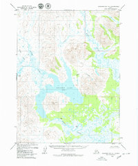
1979 Map of Goodnews Bay B-1
USGS Topo · Published 1979About this map
Wood-Tikchik State Park dominates the northern reaches of this landscape, where the headwaters of the Weary River and numerous glacial tributaries carve through the terrain. The hydrological network is the defining characteristic of the region, anchored by the expansive waters of Nunavaugaluk Lake in the southeast and a portion of Lake Aleknagik to the northeast. Mapping from the 1970s reveals a wilderness largely devoid of roads or permanent settlements, emphasizing the natural drainages of Sunshine Valley and naming smaller features like Gorge Creek, Lillie Creek, and Youth Creek. This survey captures the area in its raw state shortly after the park's establishment, providing a baseline for the environmental history of the Dillingham region before modern recreational development intensified.
Find a feature on this map
12 named features on this map. Tap any name to fly to it.
Don’t see what you’re looking for? This feature index may not catch every label — zoom into the map to look around manually.
Map Details
Editions of this 1979 Goodnews Bay B-1 Map
This is the sole edition of this map. No revisions or reprints were ever made.
Other maps of this area

1951 · Dillingham
USGS Topo · 1:250,000

1951 · Goodnews
USGS Topo · 1:250,000

1952 · Dillingham A-8
USGS Topo · 1:63,360

1954 · Goodnews C-2
USGS Topo · 1:63,360

1954 · Dillingham
USGS Topo · 1:250,000

1954 · Dillingham B-8
USGS Topo · 1:63,360

1954 · Dillingham C-8
USGS Topo · 1:63,360
1979 · Goodnews Bay A-1
USGS Topo · 1:63,360

1979 · Goodnews Bay B-2
USGS Topo · 1:63,360

1979 · Goodnews Bay
USGS Topo · 1:250,000