
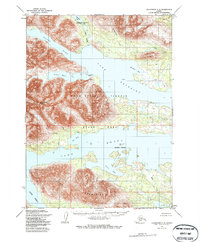
1954 Map of Dillingham C-8
USGS Topo · Published 1969About this map
Lake Beverley and Lake Nerka dominate this sub-arctic landscape, where massive bodies of water are carved into the earth by glacial activity and surrounded by prominent heights like the Frog Mountains. Based on photogrammetric methods from 1957 and field annotations from 1954, the map reveals a wilderness that relied on the Peace River to connect these major lakes. While largely uninhabited, the presence of a few scattered cabins along the water's edge at Ott Bay and the river banks suggests the seasonal movement of trappers or hunters through this remote terrain. Prominent landmarks such as Akuluktok Peak and Elbow Point served as essential navigation markers for those traveling by boat or on foot. The intricate shorelines of Hardluck Bay and Anvil Bay further illustrate the complex hydrology of this region before any modern development altered the drainage patterns of the Golden Horn or Silver Horn.
Find a feature on this map
18 named features on this map. Tap any name to fly to it.
Don’t see what you’re looking for? This feature index may not catch every label — zoom into the map to look around manually.
Map Details
Editions of this 1954 Dillingham C-8 Map
2 editions found
Other maps of this area

1951 · Dillingham
USGS Topo · 1:250,000

1951 · Goodnews
USGS Topo · 1:250,000

1954 · Dillingham
USGS Topo · 1:250,000

1954 · Dillingham D-7
USGS Topo · 1:63,360

1954 · Dillingham B-7
USGS Topo · 1:63,360

1954 · Dillingham B-8
USGS Topo · 1:63,360

1954 · Dillingham D-8
USGS Topo · 1:63,360

1954 · Dillingham C-7
USGS Topo · 1:63,360

1979 · Goodnews Bay D-1
USGS Topo · 1:63,360

1979 · Goodnews Bay B-1
USGS Topo · 1:63,360