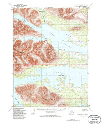
1954 Map of Dillingham C-8
USGS Topo · Published 1985About this map
Golden Horn Lake and Beverley Lake dominate this mid-century topographic portrait of the Alaskan interior, showing a landscape defined by water and high peaks. The 1954 annotations identify essential hubs of remote activity such as the Golden Horn Lodge and a nearby Seaplane Anchorage on Mitchalk Lake, which highlight the importance of air travel in this roadless region. Significant portions of the terrain fall within the Wood River Tikchik State Park, where the Wood River Mountains rise to landmarks like Akuluktok Peak. Numerous bays and inlets, including Silver Horn, Hardluck Bay, and Anvil Bay, break the massive shorelines, while smaller cabins along the Peace River and Joe Creek signal the presence of trappers, hunters, or seasonal residents in the wilderness.
Find a feature on this map
23 named features on this map. Tap any name to fly to it.
Don’t see what you’re looking for? This feature index may not catch every label — zoom into the map to look around manually.
Map Details
Editions of this 1954 Dillingham C-8 Map
2 editions found
Other maps of this area

1951 · Dillingham
USGS Topo · 1:250,000

1951 · Goodnews
USGS Topo · 1:250,000

1954 · Dillingham
USGS Topo · 1:250,000

1954 · Dillingham D-7
USGS Topo · 1:63,360

1954 · Dillingham B-7
USGS Topo · 1:63,360

1954 · Dillingham B-8
USGS Topo · 1:63,360

1954 · Dillingham D-8
USGS Topo · 1:63,360

1954 · Dillingham C-7
USGS Topo · 1:63,360

1954 · Dillingham C-8
USGS Topo · 1:63,360

1979 · Goodnews Bay D-1
USGS Topo · 1:63,360