
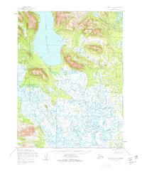
1952 Map of Dillingham A-8
USGS Topo · Published 1963About this map
Lake Nunavaugaluk dominates the northern landscape of this 1952 study, its deep waters framed by sharp elevation contours. South of the lake, the terrain transitions into an intricate network of wetlands where the Snake River and Weary River meander through a broad Tidal Flat. The intricate waterways suggest a landscape defined by seasonal hydrologic shifts, where travel and survival were dictated by the flow of these glacial and tidal systems.
Find a feature on this map
6 named features on this map. Tap any name to fly to it.
Don’t see what you’re looking for? This feature index may not catch every label — zoom into the map to look around manually.
Map Details
Editions of this 1952 Dillingham A-8 Map
2 editions found
Other maps of this area

1945 · Nushagak Bay
USGS Topo · 1:250,000

1948 · Nushagak Bay D-4
USGS Topo · 1:63,360

1948 · Nushagak Bay D-3
USGS Topo · 1:63,360

1949 · Nushagak Bay
USGS Topo · 1:250,000

1951 · Dillingham
USGS Topo · 1:250,000

1951 · Goodnews
USGS Topo · 1:250,000

1951 · Nushagak Bay
USGS Topo · 1:250,000

1952 · Nushagak Bay D-3
USGS Topo · 1:63,360

1952 · Nushagak Bay D-4
USGS Topo · 1:63,360

1952 · Dillingham A-7
USGS Topo · 1:63,360