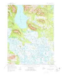
1952 Map of Dillingham A-8
USGS Topo · Published 1963About this map
Lake Nunavaugaluk dominates the northern reaches of this coastal Alaskan landscape, transitioning into a dense network of meandering waterways and wetlands to the south. The complex hydrology is defined by the winding paths of the Snake River and Weary River, which snake through an area of extensive Tidal Flats. Sparse human presence is evidenced by isolated Cabins, indicating a landscape primarily shaped by seasonal subsistence or trapping rather than permanent industrial development. The drainage patterns of Salmon Creek and other tributaries illustrate the intricate terrain typical of the Bristol Bay region during the early 1950s, compiled from aerial photography and hydrographic charts by the Army Map Service and the Coast and Geodetic Survey.
Find a feature on this map
6 named features on this map. Tap any name to fly to it.
Don’t see what you’re looking for? This feature index may not catch every label — zoom into the map to look around manually.
Map Details
Editions of this 1952 Dillingham A-8 Map
2 editions found
Other maps of this area

1945 · Nushagak Bay
USGS Topo · 1:250,000

1948 · Nushagak Bay D-4
USGS Topo · 1:63,360

1948 · Nushagak Bay D-3
USGS Topo · 1:63,360

1949 · Nushagak Bay
USGS Topo · 1:250,000

1951 · Dillingham
USGS Topo · 1:250,000

1951 · Goodnews
USGS Topo · 1:250,000

1951 · Nushagak Bay
USGS Topo · 1:250,000

1952 · Nushagak Bay D-3
USGS Topo · 1:63,360

1952 · Nushagak Bay D-4
USGS Topo · 1:63,360

1952 · Dillingham A-8
USGS Topo · 1:63,360