
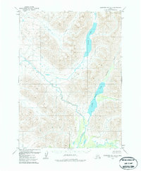
1979 Map of Goodnews Bay D-2
USGS Topo · Published 1979About this map
High Lake and Upper Togiak Lake anchor this 1979 survey of the Alaskan interior, showing a landscape defined by glacial waters and drainages. The Izavieknik River flows southward through the valley floor, serving as the primary hydrologic link between these significant water bodies. Mapping here was conducted by the U.S. Geological Survey using photogrammetric methods from 1973 aerial photography, with field annotations added in 1976. The lack of roads or established settlements emphasizes the wilderness character of the region during the late 1970s. For researchers and geologists, the map provides a precise record of the course of Trail Creek and the surrounding high-elevation terrain before modern environmental changes. The presence of these named water features suggests their importance for local navigation or seasonal activity in an otherwise roadless territory.
Find a feature on this map
4 named features on this map. Tap any name to fly to it.
Don’t see what you’re looking for? This feature index may not catch every label — zoom into the map to look around manually.
Map Details
Editions of this 1979 Goodnews Bay D-2 Map
2 editions found
Other maps of this area

1950 · Bethel
USGS Topo · 1:250,000

1951 · Goodnews
USGS Topo · 1:250,000

1954 · Goodnews C-2
USGS Topo · 1:63,360

1979 · Bethel A-3
USGS Topo · 1:63,360

1979 · Goodnews Bay D-3
USGS Topo · 1:63,360

1979 · Bethel A-1
USGS Topo · 1:63,360

1979 · Bethel A-2
USGS Topo · 1:63,360

1979 · Goodnews Bay D-1
USGS Topo · 1:63,360

1979 · Goodnews Bay C-3
USGS Topo · 1:63,360

1979 · Goodnews Bay
USGS Topo · 1:250,000