
1979 Map of Bethel A-1
USGS Topo · Published 1979About this map
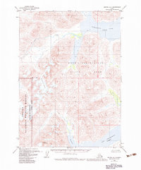
Wood-Tikchik State Park dominates this landscape in the late 1970s, showcasing the intricate transition between glacial ice and large freshwater systems. The map captures the Chikuminuk Glacier feeding towards the west while prominent water bodies like Chikuminuk Lake and Lake Chauekuktuli define the lower elevations. Rising above the basin, Konarut Mountain provides a significant landmark for orientation in a region marked by steep relief and remote drainages like Milk Creek. This survey reflects the pristine character of the region as recorded by the U.S. Geological Survey using mid-century photogrammetric methods. The presence of Shadow Bay at the southern edge of the sheet further illustrates the complex shoreline of these high-altitude lakes.
Find a feature on this map
8 named features on this map. Tap any name to fly to it.
Don’t see what you’re looking for? This feature index may not catch every label — zoom into the map to look around manually.
Map Details
Editions of this 1979 Bethel A-1 Map
2 editions found
Other maps of this area

1950 · Bethel
USGS Topo · 1:250,000

1950 · Taylor Mountains
USGS Topo · 1:250,000

1951 · Taylor Mountains
USGS Topo · 1:250,000

1951 · Dillingham
USGS Topo · 1:250,000

1951 · Goodnews
USGS Topo · 1:250,000

1954 · Taylor Mountains
USGS Topo · 1:250,000

1954 · Dillingham
USGS Topo · 1:250,000

1954 · Taylor Mountains B-8
USGS Topo · 1:63,360

1954 · Taylor Mountains A-8
USGS Topo · 1:63,360

1954 · Dillingham D-8
USGS Topo · 1:63,360