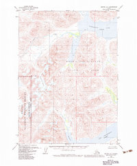
1979 Map of Bethel A-1
USGS Topo · Published 1983About this map
Wood River Tikchik State Park and the adjacent Togiak National Wildlife Refuge define this expanse of Southwestern Alaska as it was managed in the late 1970s. The landscape is dominated by high-elevation lakes and glacial features, including the sprawling Chikuminuk Lake and Lake Chauekuktuli. A significant portion of the western sheet is designated as the Togiak Wilderness, with a clearly defined Wilderness Boundary separating it from state-managed lands.
Find a feature on this map
10 named features on this map. Tap any name to fly to it.
Don’t see what you’re looking for? This feature index may not catch every label — zoom into the map to look around manually.
Map Details
Editions of this 1979 Bethel A-1 Map
2 editions found

Other maps of this area

1950 · Bethel
USGS Topo · 1:250,000

1950 · Taylor Mountains
USGS Topo · 1:250,000

1951 · Taylor Mountains
USGS Topo · 1:250,000

1951 · Dillingham
USGS Topo · 1:250,000

1951 · Goodnews
USGS Topo · 1:250,000

1954 · Taylor Mountains
USGS Topo · 1:250,000

1954 · Dillingham
USGS Topo · 1:250,000

1954 · Taylor Mountains B-8
USGS Topo · 1:63,360

1954 · Taylor Mountains A-8
USGS Topo · 1:63,360

1954 · Dillingham D-8
USGS Topo · 1:63,360