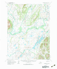
1954 Map of Goodnews B-3
USGS Topo · Published 1983About this map
Togiak River meanders through this portion of southwest Alaska, serving as the central artery for a landscape defined by its intricate hydrological network. In the mid-1950s, the settlement of Kashiagamiut sat along the river's northern bank, marking a point of human habitation in a region primarily shaped by wide glacial valleys and water. The map documents the convergence of several significant tributaries, including the Narogurum River and Kashalak River, which flow south to join the main channel. To the southeast, the terrain transitions into more pronounced elevations surrounding Pungokepuk Lake, which feeds into Pungokepuk Creek. This survey, compiled from aerial photography taken between 1952 and 1957, captures the drainage patterns of the Togiak valley before modern shifts in river morphology, providing a clear record of the area's geography and the remote position of Ongivinuk River to the east.
Find a feature on this map
7 named features on this map. Tap any name to fly to it.
Don’t see what you’re looking for? This feature index may not catch every label — zoom into the map to look around manually.
Map Details
Editions of this 1954 Goodnews B-3 Map
2 editions found
Other maps of this area

1951 · Goodnews
USGS Topo · 1:250,000

1954 · Goodnews B-3
USGS Topo · 1:63,360

1954 · Goodnews C-2
USGS Topo · 1:63,360

1954 · Goodnews C-4
USGS Topo · 1:63,360

1954 · Goodnews A-4
USGS Topo · 1:63,360

1954 · Goodnews A-3
USGS Topo · 1:63,360

1979 · Goodnews Bay B-2
USGS Topo · 1:63,360

1979 · Goodnews Bay C-3
USGS Topo · 1:63,360

1979 · Goodnews Bay
USGS Topo · 1:250,000
1979 · Goodnews Bay A-2
USGS Topo · 1:63,360