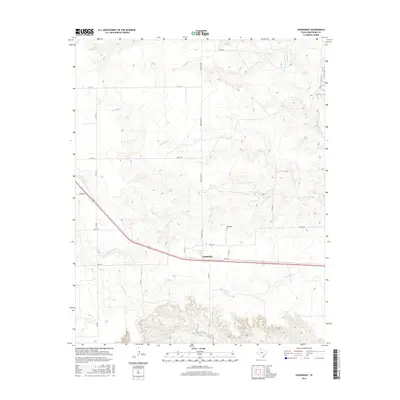
2016 Map of Goodnight
USGS Topo · Published 2016About this map
Goodnight sits at the heart of this High Plains landscape, a community defined by its proximity to the rugged canyon breaks that feed the Salt Fork Red River. The map illustrates a transition from the level ranchland above the caprock to the deeply incised drainage systems below. Tracing the courses of Patching Cr, Cottonwood Cr, and McCullum Cr, one can see how these seasonal waterways have carved out the terrain as they flow toward the main river channel in the northeast. This 2016 survey provides a modern snapshot of the local infrastructure, from the historic Goodnight Cem to the network of ranch roads like Ranch Rd 294 and Echo Rd that navigate the varied elevations of Armstrong County.
Find a feature on this map
22 named features on this map. Tap any name to fly to it.
Don’t see what you’re looking for? This feature index may not catch every label — zoom into the map to look around manually.
Map Details
Editions of this 2016 Goodnight Map
This is the sole edition of this map. No revisions or reprints were ever made.
Other maps of this area

1954 · Amarillo
USGS Topo · 1:250,000

1954 · Plainview
USGS Topo · 1:250,000

1958 · Amarillo
USGS Topo · 1:250,000

1958 · Plainview
USGS Topo · 1:250,000

1960 · Claude
USGS Topo · 1:62,500

1960 · Groom
USGS Topo · 1:62,500

1963 · Blue Hole Springs
USGS Topo · 1:24,000

1963 · Buffalo Arroyo
USGS Topo · 1:24,000

1963 · Luttrell Springs NE
USGS Topo · 1:24,000
1983 · Ashtola
USGS Topo · 1:24,000