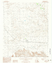
1983 Map of Goodnight
USGS Topo · Published 1984About this map
Goodnight sits at the heart of this landscape, positioned where the high plains begin their descent into the broken drainages of the Texas Panhandle. Published from 1980 field data, the map reveals a region defined by its water sources, with the Salt Fork Red River cutting through the northeast corner while various seasonal creeks like Mc Cullum Creek and Patching Creek carve through the terrain. A small Cem stands near the settlement, serving as a quiet record of early ranching families. The network of drainage patterns, including West Fork Deer Creek and the lone Spring in the south, highlights the essential role of hydrology in supporting the scattered homesteads and cattle operations of Armstrong County.
Find a feature on this map
8 named features on this map. Tap any name to fly to it.
Don’t see what you’re looking for? This feature index may not catch every label — zoom into the map to look around manually.
Map Details
Editions of this 1983 Goodnight Map
This is the sole edition of this map. No revisions or reprints were ever made.
Other maps of this area

1954 · Amarillo
USGS Topo · 1:250,000

1954 · Plainview
USGS Topo · 1:250,000

1958 · Amarillo
USGS Topo · 1:250,000

1958 · Plainview
USGS Topo · 1:250,000

1960 · Claude
USGS Topo · 1:62,500

1960 · Groom
USGS Topo · 1:62,500

1963 · Blue Hole Springs
USGS Topo · 1:24,000

1963 · Buffalo Arroyo
USGS Topo · 1:24,000

1963 · Luttrell Springs NE
USGS Topo · 1:24,000
1983 · Ashtola
USGS Topo · 1:24,000