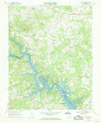
1967 Map of Goodview
USGS Topo · Published 1969About this map
Smith Mountain Lake dominates the southern landscape of this 1960s survey, its intricate shoreline filling the valleys of the Roanoke River and its many tributaries. The map documents the region's topography as the newly created reservoir transformed the local geography, where the Hales Ford Bridge crosses the water to connect the Bedford and Franklin county line. To the north, the terrain rises toward Kates Mountain and Mead Mtn, while the Norfolk and Western railroad winds through the hills, passing through a tunnel near Goodview.
Find a feature on this map
34 named features on this map. Tap any name to fly to it.
Don’t see what you’re looking for? This feature index may not catch every label — zoom into the map to look around manually.
Map Details
Editions of this 1967 Goodview Map
Other maps of this area

1890 · Roanoke
USGS Topo · 1:125,000

1891 · Roanoke
USGS Topo · 1:125,000

1929 · Roanoke
USGS Topo · 1:48,000

1933 · Roanoke
USGS Topo · 1:62,500

1947 · Roanoke
USGS Topo · 1:250,000

1950 · Peaks of Otter
USGS Topo · 1:62,500

1951 · Boones Mill
USGS Topo · 1:62,500

1951 · Moneta
USGS Topo · 1:62,500

1959 · Roanoke
USGS Topo · 1:250,000

1963 · Roanoke
USGS Topo · 1:250,000