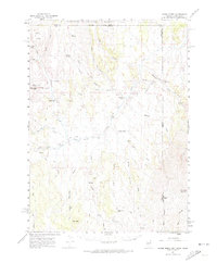
1961 Map of Goose Creek
USGS Topo · Published 1974About this map
The Old Emigrant Trail cuts across this high-desert landscape where Nevada, Idaho, and Utah meet, tracing a historic path of westward expansion. Surveyed in the early 1960s, the terrain is defined by the drainage systems of Goose Creek and its many tributaries, including Trout Creek and Meadow Creek. Sparse human activity is centered on isolated outposts such as Rancho Grande, Trout Creek Ranch, and Judd Ranch, illustrating the vast distances inherent to Great Basin ranching. Significant elevation changes are marked by Judd Mtn and Cedar Mountain, while the northern portion of the map is dominated by the Sawtooth National Forest. This map preserves the mid-century cattle-country infrastructure of the region, showing the network of jeep trails and springs like Nile Spr and Sand Spr that supported life in this corner of Elko County.
Find a feature on this map
46 named features on this map. Tap any name to fly to it.
Don’t see what you’re looking for? This feature index may not catch every label — zoom into the map to look around manually.
Map Details
Editions of this 1961 Goose Creek Map
3 editions found

Other maps of this area

1954 · Pocatello
USGS Topo · 1:250,000

1954 · Brigham City
USGS Topo · 1:250,000

1955 · Twin Falls
USGS Topo · 1:250,000

1955 · Wells
USGS Topo · 1:250,000

1958 · Wells
USGS Topo · 1:250,000

1958 · Twin Falls
USGS Topo · 1:250,000

1958 · Pocatello
USGS Topo · 1:250,000

1958 · Brigham City
USGS Topo · 1:250,000

1959 · Cotton Thomas Basin
USGS Topo · 1:62,500

1961 · Wells
USGS Topo · 1:250,000