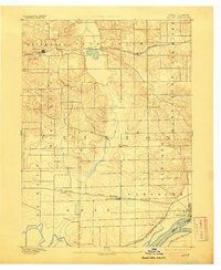
1894 Map of Goose Lake
USGS Topo · Published 1905About this map
Mississippi River frontage and the intricate rail network of Clinton County define this late 19th-century landscape. Surveyed by W. J. Peters, the map illustrates a region transitioning through agricultural development and heavy rail transit. The Chicago and North Western Railroad cuts across the northern and central sections, connecting settlements like Charlotte and Goose Lake to the broader regional economy. Further south, the Burlington Cedar Rapids and Northern R.R. and the C. M. & St. P. R. R. converge near Camanche, highlighting the town's importance as a river-and-rail hub. The terrain is shaped by Deer Creek and Brophy's Creek, which feed into the larger Wapsipinicon River system. Townships such as Deep Creek and Elk River are clearly delineated, showing the organized cadastral grid that governed land ownership and local governance during this era of Iowa's growth.
Find a feature on this map
30 named features on this map. Tap any name to fly to it.
Don’t see what you’re looking for? This feature index may not catch every label — zoom into the map to look around manually.
Map Details
Editions of this 1894 Goose Lake Map
3 editions found
Other maps of this area

1891 · DeWitt
USGS Topo · 1:62,500

1891 · Davenport
USGS Topo · 1:62,500

1891 · Maquoketa
USGS Topo · 1:62,500

1891 · Clinton
USGS Topo · 1:62,500

1892 · Goose Lake
USGS Topo · 1:62,500

1892 · Savanna
USGS Topo · 1:62,500

1892 · Leclaire
USGS Topo · 1:62,500

1893 · Leclaire
USGS Topo · 1:62,500

1894 · Goose Lake
USGS Topo · 1:62,500

1894 · Clinton
USGS Topo · 1:62,500