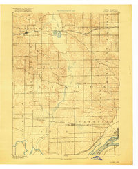
1894 Map of Goose Lake
USGS Topo · Published 1918About this map
The Mississippi River and Wapsipinicon River define the southeastern corner of this Clinton County landscape, captured by topographer W.J. Peters just before the turn of the century. The terrain reflects a transition from river lowlands near Swan Is. to the interior wetlands of Goose Lake, which feeds into Deer Creek. The regional economy of the 1890s is clearly etched in the path of the Chicago and North Western Railroad, which links the grain-collecting points of Charlotte, Low Moor, and Malone. Local transport hubs like Bryant and Camanche serve as anchors for the rural townships, while the network of roads connecting Elvira suggests a well-established agricultural community. The map provides a distinct view of Iowa's river border before modern industrial shifts, highlighting the intricate drainage patterns of Brophys Creek and the surrounding prairies.
Find a feature on this map
30 named features on this map. Tap any name to fly to it.
Don’t see what you’re looking for? This feature index may not catch every label — zoom into the map to look around manually.
Map Details
Editions of this 1894 Goose Lake Map
3 editions found
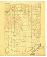
Other maps of this area

1891 · DeWitt
USGS Topo · 1:62,500

1891 · Davenport
USGS Topo · 1:62,500

1891 · Maquoketa
USGS Topo · 1:62,500

1891 · Clinton
USGS Topo · 1:62,500

1892 · Goose Lake
USGS Topo · 1:62,500

1892 · Savanna
USGS Topo · 1:62,500

1892 · Leclaire
USGS Topo · 1:62,500

1893 · Leclaire
USGS Topo · 1:62,500

1894 · Goose Lake
USGS Topo · 1:62,500

1894 · Clinton
USGS Topo · 1:62,500