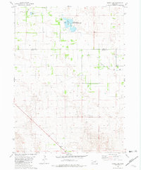
1981 Map of Goose Lake
USGS Topo · Published 1982About this map
Goose Lake State Wildlife Area centers this landscape in north-central Nebraska, straddling the boundary between Holt and Wheeler Counties. The map reveals a remote prairie environment defined by alkaline lakes and seasonal wetlands typical of the Sandhills transition. Water features like Goose Lake and Detters Lake are the primary landmarks, supported by a network of drainage including Cache Creek and Clearwater Creek. Small-scale ranching and rural settlement are evidenced by the presence of Hoerle and the Corning Sch, while several instances of a Flowing Well point to the reliance on the underlying Ogallala Aquifer. The infrastructure is minimal, consisting of isolated gravel roads, cattle fences, and a few scattered improvements like a Campground and Boat Ramp providing access to the state-managed wildlife lands.
Find a feature on this map
14 named features on this map. Tap any name to fly to it.
Don’t see what you’re looking for? This feature index may not catch every label — zoom into the map to look around manually.
Map Details
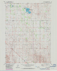
Editions of this 1981 Goose Lake Map
2 editions found
Other maps of this area

1954 · Bartlett NW
USGS Topo · 1:24,000

1954 · Bartlett
USGS Topo · 1:24,000

1955 · Broken Bow
USGS Topo · 1:250,000

1955 · O'Neill
USGS Topo · 1:250,000

1956 · Broken Bow
USGS Topo · 1:250,000

1959 · O'Neill
USGS Topo · 1:250,000

1960 · Spalding 2 NW
USGS Topo · 1:24,000

1963 · Deloit SW
USGS Topo · 1:24,000

1963 · Deloit NW
USGS Topo · 1:24,000

1969 · O'Neill
USGS Topo · 1:250,000