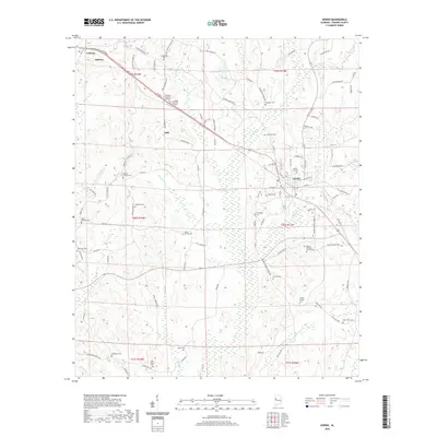
2020 Map of Gordo
USGS Topo · Published 2020About this map
Gordo and Reform anchor this rural landscape in Pickens County, where a dense network of country roads and family cemeteries reveals the deep-rooted settlement patterns of western Alabama. The map detail highlights numerous burial grounds that serve as vital records for genealogists, such as Holly Springs Cem, Old Trinity Cem, and Thrasher Cem. Small communities like Bell and Lathrop are situated among the winding headwaters of Bear Cr and Little Lubbub Cr. The terrain is defined by its many small branches and creeks, including the colorfully named Bad Luck Cr and Houten Br. These waterways, along with landmarks like Arbor Springs Cem, indicate a landscape where small-scale agriculture and timber have long shaped the local economy and social geography.
Find a feature on this map
122 named features on this map. Tap any name to fly to it.
Don’t see what you’re looking for? This feature index may not catch every label — zoom into the map to look around manually.
Map Details
Editions of this 2020 Gordo Map
This is the sole edition of this map. No revisions or reprints were ever made.
Other maps of this area

1953 · Birmingham
USGS Topo · 1:250,000

1953 · West Point
USGS Topo · 1:250,000

1956 · Birmingham
USGS Topo · 1:250,000

1957 · Birmingham
USGS Topo · 1:250,000

1958 · West Point
USGS Topo · 1:250,000

1963 · West Point
USGS Topo · 1:250,000

1967 · Carrollton
USGS Topo · 1:24,000

1967 · Brownville
USGS Topo · 1:24,000

1967 · Gordo
USGS Topo · 1:24,000
1967 · Palmetto
USGS Topo · 1:24,000