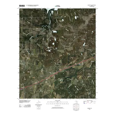
2010 Map of Gordon
USGS Topo · Published 2010About this map
Palo Pinto Creek winds through this central Texas landscape, connecting a network of local reservoirs and agricultural land. The map centers on Gordon, with nearby rural settlements like Coalville and Blue Flat providing a window into the community's historical development. The area is marked by a high concentration of burial sites, including the Old Gordon Cemetery, New Gordon Cemetery, and Swank Cemetery, which offer significant value for genealogists tracing local families. Terrain features like Swank Mountain and Clayton Mountain rise above the drainage basins of Barton Creek and Saline Creek. Transport and infrastructure are defined by Gordon Junction and the small siding at Judd Switch, illustrating the rail and road connections that sustained these small towns. The presence of Clayton Spring and numerous small dams, such as James Lake Dam, highlights the vital role of water management in this cattle and farming country.
Find a feature on this map
64 named features on this map. Tap any name to fly to it.
Don’t see what you’re looking for? This feature index may not catch every label — zoom into the map to look around manually.
Map Details
Editions of this 2010 Gordon Map
This is the sole edition of this map. No revisions or reprints were ever made.
Other maps of this area

1890 · Stephenville
USGS Topo · 1:125,000

1891 · Palo Pinto
USGS Topo · 1:125,000

1918 · Palo Pinto
USGS Topo · 1:125,000

1920 · Stephenville
USGS Topo · 1:125,000

1925 · Palo Pinto 4-b
USGS Topo · 1:48,000

1931 · Santo
USGS Topo · 1:62,500

1954 · Abilene
USGS Topo · 1:250,000

1958 · Abilene
USGS Topo · 1:250,000
1959 · Lipan
USGS Topo · 1:62,500

1959 · Gordon
USGS Topo · 1:62,500