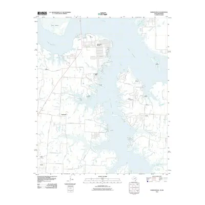
2010 Map of Gordonville
USGS Topo · Published 2010About this map
Lake Texoma dominates the northern and eastern reaches of this Texas-Oklahoma borderlands survey, defining the landscape through its complex shoreline and the expansive Big Mineral Arm. The map documents a blend of lakeside recreation and long-standing rural communities. Settlements like Sherwood Shores and Gordonville sit alongside numerous youth and group camps such as Camp Grayson, Camp Texoma, and Camp Rio Roxo. Inland, the agricultural and industrial character of Grayson County remains evident through the Sandusky Oil Field and a network of county roads. For genealogists, the map preserves the locations of several community burial grounds, including Noel Cemetery, Locust Cemetery, and Mount Tabor Cemetery. The terrain is marked by numerous watercourses feeding the reservoir, such as Walnut Creek and Cedar Creek, while land features like Juniper Point and Fobb Bottom provide specific landmarks for those tracing family property or local history in this river valley region.
Find a feature on this map
68 named features on this map. Tap any name to fly to it.
Don’t see what you’re looking for? This feature index may not catch every label — zoom into the map to look around manually.
Map Details
Editions of this 2010 Gordonville Map
This is the sole edition of this map. No revisions or reprints were ever made.
Other maps of this area

1901 · Denison
USGS Topo · 1:125,000

1954 · Sherman
USGS Topo · 1:250,000

1958 · Gordonville
USGS Topo · 1:62,500

1958 · Denison Dam
USGS Topo · 1:62,500

1958 · Sherman NW
USGS Topo · 1:24,000

1958 · Whitesboro
USGS Topo · 1:62,500

1958 · Sherman
USGS Topo · 1:250,000

1958 · Sherman
USGS Topo · 1:62,500
1976 · Gordonville NE
USGS Topo · 1:24,000
1976 · Gordonville SE
USGS Topo · 1:24,000