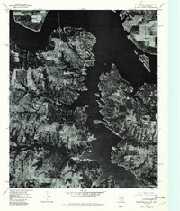
1976 Map of Gordonville SE
USGS Topo · Published 1979About this map
The Big Mineral Arm of Lake Texoma dominates this mid-1970s orthophotograph, where the deep waters of the reservoir reach into the Texas countryside. This aerial survey, captured in late 1976, provides a literal overhead view of the shoreline and land use patterns along the Oklahoma-Texas border. The settlement of Gordonville sits just west of the main waterway, while Locust is positioned on the eastern peninsula. Further north, the shoreline curls around Cedar Mills, illustrating the relationship between these small communities and the irregular, flooded topography of the lake. The imagery clearly distinguishes between the dense wooded areas along the inlets and the rectangular grids of agricultural fields and pastures that extend away from the water’s edge, offering a clear record of the region's development during this era.
Find a feature on this map
5 named features on this map. Tap any name to fly to it.
Don’t see what you’re looking for? This feature index may not catch every label — zoom into the map to look around manually.
Map Details
Editions of this 1976 Gordonville SE Map
This is the sole edition of this map. No revisions or reprints were ever made.
Other maps of this area

1901 · Denison
USGS Topo · 1:125,000

1954 · Sherman
USGS Topo · 1:250,000

1958 · Gordonville
USGS Topo · 1:62,500

1958 · Denison Dam
USGS Topo · 1:62,500

1958 · Sherman NW
USGS Topo · 1:24,000

1958 · Whitesboro
USGS Topo · 1:62,500

1958 · Sherman
USGS Topo · 1:250,000

1958 · Sherman
USGS Topo · 1:62,500
1976 · Gordonville NE
USGS Topo · 1:24,000
1976 · Gordonville SW
USGS Topo · 1:24,000