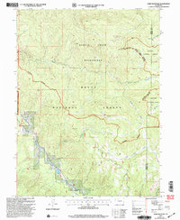
2000 Map of Gore Mountain
USGS Topo · Published 2004About this map
Gore Mountain and the Morrison Divide anchor this high-elevation landscape at the turn of the 21st century, marking a significant boundary between the Routt National Forest and Arapaho National Forest. The map detail reveals a complex network of alpine drainage systems, with Sarvis Creek and Silver Creek flowing through the protected Sarvis Creek Wilderness. This territory is defined by its topographic extremes rather than human settlement, serving as a vital watershed where the South Fork Rock Creek and Tepee Creek navigate the steep gradients of the southern Rocky Mountains. The alignment of forest and wilderness boundaries illustrates late-century conservation management across the Routt and Grand County line, preserving a landscape where geography dictates the few unimproved routes such as those near Red Dirt Cr.
Find a feature on this map
18 named features on this map. Tap any name to fly to it.
Don’t see what you’re looking for? This feature index may not catch every label — zoom into the map to look around manually.
Map Details
Editions of this 2000 Gore Mountain Map
This is the sole edition of this map. No revisions or reprints were ever made.
Other maps of this area

1954 · Craig
USGS Topo · 1:250,000

1956 · Lake Agnes
USGS Topo · 1:24,000

1956 · Walton Peak
USGS Topo · 1:24,000

1956 · Gore Pass
USGS Topo · 1:62,500

1956 · Rabbit Ears Peak
USGS Topo · 1:62,500

1957 · Craig
USGS Topo · 1:250,000

1958 · Craig
USGS Topo · 1:250,000

1960 · Craig
USGS Topo · 1:250,000

1962 · Craig
USGS Topo · 1:250,000

1964 · Craig
USGS Topo · 1:250,000