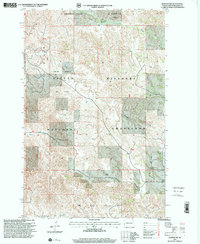
1997 Map of Gorham NW
USGS Topo · Published 2001About this map
Elkhorn Ranch and the winding course of the Little Missouri river define this landscape in Billings County, where private ranching and industrial resource extraction coexist within the Little Missouri National Grassland. The map reveals a complex mosaic of land use in the late 1990s, where several major petroleum deposits, including the Magpie Oil Field and the Anderson Coulee Oil Field, are interspersed with traditional homesteads. The rugged drainage systems of Blacktail Creek, Whitetail Creek, and Mikes Creek cut through the terrain, leading toward the river. Local landmarks like Kessel Ranch and the Kordon Ranch highlight the continued importance of the ranching economy, while the presence of a Compressor Station and a Scoria Pit reflect the area's active energy infrastructure during this period of revision by the Forest Service.
Find a feature on this map
17 named features on this map. Tap any name to fly to it.
Don’t see what you’re looking for? This feature index may not catch every label — zoom into the map to look around manually.
Map Details
Editions of this 1997 Gorham NW Map
This is the sole edition of this map. No revisions or reprints were ever made.
Other maps of this area

1953 · Watford City
USGS Topo · 1:250,000

1957 · Watford City
USGS Topo · 1:250,000

1963 · Gorham SW
USGS Topo · 1:24,000

1963 · Gorham NW
USGS Topo · 1:24,000

1963 · Gorham SE
USGS Topo · 1:24,000

1963 · Gorham
USGS Topo · 1:24,000

1967 · Watford City
USGS Topo · 1:250,000

1970 · Hanks Gully
USGS Topo · 1:24,000

1970 · Wannagan Creek East
USGS Topo · 1:24,000

1970 · Roosevelt Creek East
USGS Topo · 1:24,000