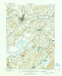
1906 Map of Goshen
USGS Topo · Published 1963About this map
Middletown and Goshen serve as the primary hubs in this early twentieth-century survey of Orange County, where a dense network of rail lines and water management systems shaped the local economy. The Erie RR and the New York Ontario and Western RR intersect the landscape, connecting specialized dairy and agricultural communities like Campbell Hall and New Hampton. A striking feature of the southern terrain is the Commissioners Ditch, a major drainage project designed to reclaim the fertile but marshy bottomlands of the Wallkill River valley near Pellets Island. From the industrial corridors of Mechanicstown to the remote hills of Brimstone Mtn, the map reveals a landscape in transition, where natural barriers like Pumpkin Swamp Creek were being engineered into productive farmland, and small stops such as Wisner PO anchored rural life.
Find a feature on this map
105 named features on this map. Tap any name to fly to it.
Don’t see what you’re looking for? This feature index may not catch every label — zoom into the map to look around manually.
Map Details
Editions of this 1906 Goshen Map
2 editions found

Other maps of this area

1888 · Franklin
USGS Topo · 1:62,500

1891 · Greenwood Lake
USGS Topo · 1:62,500

1891 · Ramapo
USGS Topo · 1:62,500

1893 · Greenwood Lake
USGS Topo · 1:62,500

1893 · Ramapo
USGS Topo · 1:62,500

1894 · Franklin
USGS Topo · 1:62,500

1897 · Franklin
USGS Topo · 1:62,500

1902 · Schunemunk
USGS Topo · 1:62,500

1903 · Newburg
USGS Topo · 1:62,500

1903 · Franklin Furnace
USGS Topo · 1:62,500