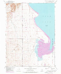
1950 Map of Goshen Valley North
USGS Topo · Published 1978About this map
Utah Lake defines the eastern edge of this landscape, its shoreline captured here during mid-century surveys that recorded a water elevation of 4487 feet in September 1949. The map details the transition from the lake's edge into the agricultural and desert terrain of Goshen Valley, where drainage and irrigation patterns are central to the land's utility. Of particular interest to local historians is the Abandoned Canal winding through the western hills near Coyote Pass, tracing a defunct water route that once supported earlier settlement efforts. To the southeast, the Genola Town Boundary and the Salt Lake Meridian establish the formal survey lines of the region. From the seasonal flow of Pinyon Creek to the presence of a lone Pump and a small Reservoir, the map documents the persistent human effort to manage water in this arid Utah environment.
Find a feature on this map
10 named features on this map. Tap any name to fly to it.
Don’t see what you’re looking for? This feature index may not catch every label — zoom into the map to look around manually.
Map Details
Editions of this 1950 Goshen Valley North Map
3 editions found
Other maps of this area

1885 · Salt Lake
USGS Topo · 1:250,000

1885 · Manti
USGS Topo · 1:250,000

1885 · Sevier Desert
USGS Topo · 1:250,000

1885 · Tooele Valley
USGS Topo · 1:250,000

1895 · Manti
USGS Topo · 1:250,000

1947 · Fivemile Pass
USGS Topo · 1:62,500

1947 · Allens Ranch
USGS Topo · 1:24,000

1947 · Goshen Pass
USGS Topo · 1:24,000

1949 · Eureka
USGS Topo · 1:24,000

1949 · Allens Ranch
USGS Topo · 1:24,000