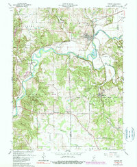
1965 Map of Gosport
USGS Topo · Published 1983About this map
White River meanders through the heart of this landscape, carving a wide valley that separates the town of Gosport from the industrial limestone operations near Stinesville. The terrain is defined by the sharp transition between the river lowlands and the uplands of Mc Cormicks Creek State Park, where McCormicks Creek cuts through steep bluffs near Wolf Cave. Cultural history is anchored by numerous rural landmarks, including the Old Dutch Ch and the Silex Cem overlooking the river valley. The transportation network is remarkably dense for the era, featuring the Monon Railroad and lines now designated as Conrail, which supported the region's prominent quarrying industry. From the Drive-in Theater near Cuba to the Lookout Tower in the state park, the map illustrates a mid-century Indiana crossroads where recreational spaces, small-town life, and heavy stone extraction coexisted.
Find a feature on this map
66 named features on this map. Tap any name to fly to it.
Don’t see what you’re looking for? This feature index may not catch every label — zoom into the map to look around manually.
Map Details
Editions of this 1965 Gosport Map
4 editions found
Other maps of this area

1908 · Bloomington
USGS Topo · 1:48,000

1908 · Bloomfield
USGS Topo · 1:62,500

1910 · Bloomington
USGS Topo · 1:62,500

1947 · Gosport
USGS Topo · 1:24,000

1949 · Quincy
USGS Topo · 1:24,000

1950 · Gosport
USGS Topo · 1:24,000

1953 · Indianapolis
USGS Topo · 1:250,000

1956 · Indianapolis
USGS Topo · 1:250,000

1956 · Cataract
USGS Topo · 1:24,000

1956 · Freedom
USGS Topo · 1:24,000