
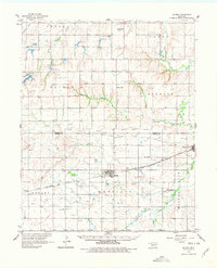
1961 Map of Gotebo
USGS Topo · Published 1962About this map
The Chicago Rock Island and Pacific railroad bisects this Oklahoma landscape, connecting the agricultural hubs of Gotebo and Mountain View. This 1961 survey provides a detailed view of the rural landscape along the Washita River, where family-named landmarks and country churches define the community structure. An Old Indian Boundary runs east-west through the center of the sheet, reflecting the complex history of land allotment and tribal territories in the region. Near the foothills of Rainy Mountain, genealogists will find several notable burial sites including the Rainy Mountain Indian Mission Cemetery and the Wyatt Cemetery. The development of local industry is marked by numerous Oil Wells and a Gravel Pit near the tracks, while smaller settlements like Lake Valley and Komalty serve as centers for the surrounding prairie homesteads.
Find a feature on this map
42 named features on this map. Tap any name to fly to it.
Don’t see what you’re looking for? This feature index may not catch every label — zoom into the map to look around manually.
Map Details
Editions of this 1961 Gotebo Map
2 editions found
Other maps of this area

1949 · Cooperton
USGS Topo · 1:62,500

1950 · Saddle Mountain
USGS Topo · 1:62,500

1955 · Lawton
USGS Topo · 1:250,000

1955 · Clinton
USGS Topo · 1:250,000

1956 · Cordell
USGS Topo · 1:62,500

1956 · Bally Mountain
USGS Topo · 1:24,000

1956 · Unap Mountain
USGS Topo · 1:24,000

1956 · Rainy Mountain Creek
USGS Topo · 1:24,000

1956 · Saddle Mountain
USGS Topo · 1:62,500

1956 · Cooperton
USGS Topo · 1:62,500