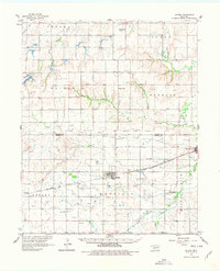
1961 Map of Gotebo
USGS Topo · Published 1978About this map
The Old Indian Treaty Boundary bisects this portion of the Oklahoma plains, marking a significant historical line across the landscape between Washita Co and Kiowa Co. At the heart of the region lies the Chicago Rock Island and Pacific railroad, which anchors the settlements of Gotebo and Mountain View. The map reveals a deeply established cultural landscape, particularly centered around the Rainy Mountain Indian Mission and the nearby Rainy Mtn Indian Sch to the south.
Find a feature on this map
47 named features on this map. Tap any name to fly to it.
Don’t see what you’re looking for? This feature index may not catch every label — zoom into the map to look around manually.
Map Details
Editions of this 1961 Gotebo Map
2 editions found

Other maps of this area

1949 · Cooperton
USGS Topo · 1:62,500

1950 · Saddle Mountain
USGS Topo · 1:62,500

1955 · Lawton
USGS Topo · 1:250,000

1955 · Clinton
USGS Topo · 1:250,000

1956 · Cordell
USGS Topo · 1:62,500

1956 · Bally Mountain
USGS Topo · 1:24,000

1956 · Unap Mountain
USGS Topo · 1:24,000

1956 · Rainy Mountain Creek
USGS Topo · 1:24,000

1956 · Saddle Mountain
USGS Topo · 1:62,500

1956 · Cooperton
USGS Topo · 1:62,500