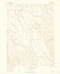
1955 Map of Gould
USGS Topo · Published 1963About this map
The Michigan River valley serves as the primary artery for settlement and administration in this 1955 survey of north-central Colorado. The small community of Gould is anchored by the Michigan River Ranger Station, marking the intersection of public land management and local ranching life. The landscape is a complex network of high-country irrigation, with numerous ditches and flumes such as the Riley Ext Ditch and Mason Ditch carved into the slopes of Custer Mountain and Owl Mountain. These waterworks supported a series of family-held properties including the Stelbars Connor Ranch, Overton Ranch, and Lobau Ranch.
Find a feature on this map
36 named features on this map. Tap any name to fly to it.
Don’t see what you’re looking for? This feature index may not catch every label — zoom into the map to look around manually.
Map Details
Editions of this 1955 Gould Map
5 editions found
Other maps of this area

1915 · Longs Peak
USGS Topo · 1:125,000

1916 · Home
USGS Topo · 1:125,000

1919 · Rocky Mountain National Park
USGS Topo · 1:125,000

1920 · Home
USGS Topo · 1:125,000

1954 · Greeley
USGS Topo · 1:250,000

1954 · Craig
USGS Topo · 1:250,000

1955 · Gould
USGS Topo · 1:24,000

1955 · Owl Ridge
USGS Topo · 1:24,000

1955 · Gould NW
USGS Topo · 1:24,000

1956 · Johnny Moore Mountain
USGS Topo · 1:24,000