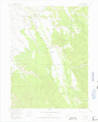
1955 Map of Gould
USGS Topo · Published 1971About this map
The high country of Jackson County is defined by its ranching heritage and the headwaters of the Michigan River in this mid-century survey. Families working this landscape are recorded through numerous named properties such as Stelbars Michigan River Ranch, Haworth Ranch, and the Johnson Ranch. The small settlement of Gould serves as a local hub near the Michigan River Ranger Sta, while education in this remote mountain terrain is represented by the Michigan Hill Sch. Higher elevations are dominated by the peaks of Custer Mountain and Owl Mountain, where the boundaries of the Routt National Forest and the Colorado State Forest converge. This area also serves as a recreational destination, featuring the Aspen Campground and the Cameron Pass 4-H Club Camp near the South Fork Michigan River.
Find a feature on this map
38 named features on this map. Tap any name to fly to it.
Don’t see what you’re looking for? This feature index may not catch every label — zoom into the map to look around manually.
Map Details
Editions of this 1955 Gould Map
5 editions found
Other maps of this area

1915 · Longs Peak
USGS Topo · 1:125,000

1916 · Home
USGS Topo · 1:125,000

1919 · Rocky Mountain National Park
USGS Topo · 1:125,000

1920 · Home
USGS Topo · 1:125,000

1954 · Greeley
USGS Topo · 1:250,000

1954 · Craig
USGS Topo · 1:250,000

1955 · Gould
USGS Topo · 1:24,000

1955 · Owl Ridge
USGS Topo · 1:24,000

1955 · Gould NW
USGS Topo · 1:24,000

1956 · Johnny Moore Mountain
USGS Topo · 1:24,000