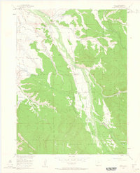
1955 Map of Gould
USGS Topo · Published 1963About this map
Michigan River headwaters define the character of this mid-century high-altitude landscape, where ranching and forestry intersect on the edge of the Routt National Forest and the Colorado State Forest. The settlement of Gould sits as a central node in a valley floor crisscrossed by an intricate network of irrigation channels like the Overland Ditch, Longhorn Ditch, and Domestic Supply Ditch. These diversions illustrate the intensive water management required to support mountain ranching at sites such as the Stelbars Michigan River Ranch and Riley Ranch. Social and administrative hubs are clearly marked, including the Haworth Sch, the Michigan River Ranger Sta, and the Cameron Pass 4-H Club Camp. The terrain is framed by the massive rises of Custer Mountain and Owl Mountain, showing a transition from valley agriculture to protected forest land.
Find a feature on this map
57 named features on this map. Tap any name to fly to it.
Don’t see what you’re looking for? This feature index may not catch every label — zoom into the map to look around manually.
Map Details
Editions of this 1955 Gould Map
5 editions found
Other maps of this area

1915 · Longs Peak
USGS Topo · 1:125,000

1916 · Home
USGS Topo · 1:125,000

1919 · Rocky Mountain National Park
USGS Topo · 1:125,000

1920 · Home
USGS Topo · 1:125,000

1954 · Greeley
USGS Topo · 1:250,000

1954 · Craig
USGS Topo · 1:250,000

1955 · Gould
USGS Topo · 1:24,000

1955 · Owl Ridge
USGS Topo · 1:24,000

1955 · Gould NW
USGS Topo · 1:24,000

1956 · Johnny Moore Mountain
USGS Topo · 1:24,000