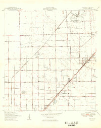
1949 Map of Goulds
USGS Topo · Published 1949About this map
The U S Naval Air Station dominates the northeastern corner of this South Florida landscape, just before the post-war suburban boom transformed the region. Captured in the late 1940s, the area is defined by a grid of agricultural roads and the primary rail corridors of the Florida East Coast and Seaboard Air Line. Distinctive local settlements like Aladdin City and Silver Palm represent the community hubs of the era, while specialized landmarks such as the Redland Dist Sch and Full Gospel Mission Ch reveal the social fabric of the district. The terrain is marked by small hammocks and groves, with named tracks like Quail Roost Drive and Silver Palm Drive cutting through the fruit-growing country. From the Naranja Cemetery to the small siding at Modello, the map documents the transition between industrial military use and the citrus-based economy of Dade County.
Find a feature on this map
31 named features on this map. Tap any name to fly to it.
Don’t see what you’re looking for? This feature index may not catch every label — zoom into the map to look around manually.
Map Details
Editions of this 1949 Goulds Map
2 editions found
Other maps of this area

1949 · South Miami NW
USGS Topo · 1:24,000

1949 · Arsenicker Keys
USGS Topo · 1:24,000

1949 · Goulds
USGS Topo · 1:24,000

1949 · Perrine
USGS Topo · 1:24,000

1950 · Homestead
USGS Topo · 1:24,000

1950 · South Miami
USGS Topo · 1:24,000

1955 · South Miami NW
USGS Topo · 1:24,000

1956 · Goulds
USGS Topo · 1:24,000

1956 · Perrine
USGS Topo · 1:24,000

1956 · South Miami
USGS Topo · 1:24,000
Featured Places
- Princeton, FL
- Goulds, FL
- Naranja, FL
- Leisure Mobile Home Park-Modello Park, FL
- Pine Isle Mobile Home Park, FL