
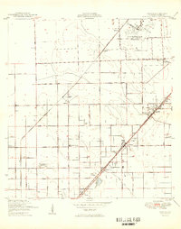
1949 Map of Goulds
USGS Topo · Published 1949About this map
The U S Naval Air Station dominates the northern landscape of this South Florida survey, reflecting the region's military significance in the years immediately following the war. Two major railroads, the Florida East Coast and the Seaboard Air Line, intersect the territory, driving the development of agricultural centers like Goulds, Princeton, and Naranja. This period shows a transition from rural groves to more structured settlements, where local life centered around the Redland Dist Sch and community landmarks such as the Redland Community Ch and St Johns Ch. The map also captures the natural character of the area through features like the Bauer Drive Hammock, illustrating the pockets of tropical vegetation that remained amid the growing network of section roads like Krome Ave and Eureka Drive.
Find a feature on this map
39 named features on this map. Tap any name to fly to it.
Don’t see what you’re looking for? This feature index may not catch every label — zoom into the map to look around manually.
Map Details
Editions of this 1949 Goulds Map
2 editions found
Other maps of this area

1949 · South Miami NW
USGS Topo · 1:24,000

1949 · Arsenicker Keys
USGS Topo · 1:24,000

1949 · Perrine
USGS Topo · 1:24,000

1950 · Homestead
USGS Topo · 1:24,000

1950 · South Miami
USGS Topo · 1:24,000

1955 · South Miami NW
USGS Topo · 1:24,000

1956 · Goulds
USGS Topo · 1:24,000

1956 · Perrine
USGS Topo · 1:24,000

1956 · South Miami
USGS Topo · 1:24,000

1956 · Grossman Hammock
USGS Topo · 1:24,000
Featured Places
- Princeton, FL
- Goulds, FL
- Naranja, FL
- Leisure Mobile Home Park-Modello Park, FL
- Pine Isle Mobile Home Park, FL