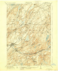
1915 Map of Gouverneur
USGS Topo · Published 1928About this map
Gouverneur serves as the industrial and population hub of this St. Lawrence County landscape, situated where the Oswegatchie River carves through the terrain. The map captures an era of diverse rural enterprise, from the Fullerville Ironworks in the south to the Hailes Hopyard near Hailesboro. The importance of water power and early manufacturing is evident at Natural Dam and the various mills implied by settlements like Emeryville and Taleville.
Find a feature on this map
81 named features on this map. Tap any name to fly to it.
Don’t see what you’re looking for? This feature index may not catch every label — zoom into the map to look around manually.
Map Details
Editions of this 1915 Gouverneur Map
4 editions found
Other maps of this area

1904 · Ogdensburg
USGS Topo · 1:62,500

1905 · Ogdensburg
USGS Topo · 1:62,500

1906 · Brier Hill
USGS Topo · 1:62,500

1910 · Canton
USGS Topo · 1:62,500

1911 · Canton
USGS Topo · 1:62,500

1911 · Antwerp
USGS Topo · 1:62,500

1912 · Hammond
USGS Topo · 1:62,500

1913 · Lake Bonaparte
USGS Topo · 1:62,500

1915 · Gouverneur
USGS Topo · 1:62,500

1915 · Russell
USGS Topo · 1:62,500